
Before we can celebrate the carbon a forest will capture, it helps to have a clear picture of what was there before the first tree went in.
That's the work our Environment Team has been doing this month, as we prepare to onboard our very first Foundation project in Chile: Restoring Biodiversity Highways, a project that will turn a series of bare, pre-planting plots into thriving ecological corridors.
Why a Baseline Matters
A carbon baseline is the reference point against which future growth is measured. The more systematic and independently derived that reference point is, the stronger the case we can make for the impact that follows, a clear, well-documented "before" picture to set against the "after." Our Foundation projects are introducing exactly that: a more repeatable, satellite-derived baseline and monitoring layer, built directly into how we onboard new sites.
For a pre-planting site, a low existing baseline isn't an ecological ideal; these are degraded or cleared plots in need of restoration, which is precisely why they were selected for planting in the first place. But from a measurement standpoint, a low, flat baseline makes it much easier to attribute future carbon growth clearly to the restoration work itself, rather than to biomass that was already there. That clarity is what we're looking for as we screen candidate plots in Chile.
The Tool: Planet's Platform
To measure this objectively, our team turned to Planet's Platform, using its Aboveground Carbon Density (3-month composite) dataset. This satellite-derived layer estimates aboveground carbon density (in MgC/ha) across a polygon at regular three-month intervals, letting us track the trend over a full year rather than relying on a single snapshot. It's a density reading, not a total carbon stock for the site.
A quick note on units: MgC/ha stands for megagrams of carbon per hectare, and since one megagram equals one metric tonne, that is simply "tonnes of carbon per hectare". To convert that into tonnes of CO₂ captured per hectare (tCO₂e/ha), we multiply by 3.67, the ratio between the molecular weight of CO₂ and that of carbon.
For each site, we record two figures: the Current Measurement (the most recent reading) and the AGC Change, the shift in Aboveground Carbon Density over the baseline year:
AGC Change = (Current Measurement) − (Baseline Year Measurement)
A value near zero tells us the site has been sitting flat, with little natural regeneration or degradation. Each figure is sourced directly from Aboveground Carbon Density, Planet Forest Carbon Monitoring (3m), 2026 Planet Labs PBC, and reviewed and approved by our Environment Team before it's logged.
What We Found Across the Sites
Our team reviewed some candidate plots; here's a look at some of the planting sites within the project.
A Gentle Upward Trend
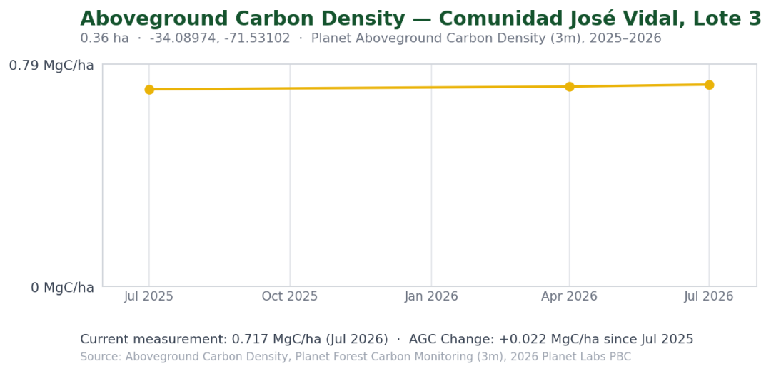
Carbon values on the planting site Comunidad José Vidal, Lote 3 (2026) held close to flat, from around 0.70 MgC/ha in July 2025 to a Current Measurement of roughly 0.72 MgC/ha (≈2.64 tCO₂e/ha) by July 2026 (with a couple of data gaps along the way), as can be seen in the image below. That gives an AGC Change of +0.022 MgC/ha (≈+0.08 tCO₂e/ha), a difference this small can fall within the range of normal model variability, and we can say no material change is detectable in the Planet series over the period reviewed.
About as Flat as It Gets
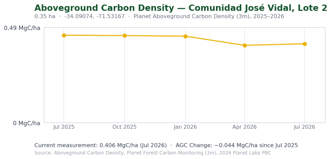
The planting site Comunidad José Vidal, Lote 2 (2026) held steady near 0.45 MgC/ha for most of the year before stepping down slightly to a Current Measurement of about 0.40 MgC/ha around April 2026, holding through July, shown in the chart below. The resulting AGC Change is slightly negative (−0.044 MgC/ha); as with the other sites, a difference of this size doesn't confirm a shift in ground conditions on its own, but it's consistent with a low, pre-restoration carbon baseline.
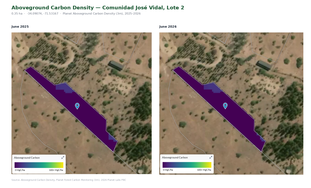
The satellite comparison below shows the site in June 2025 and June 2026 side by side. Visually, the polygon looks almost identical across the two years, consistent with the modest AGC Change measured for this period.
The Highest Existing Biomass
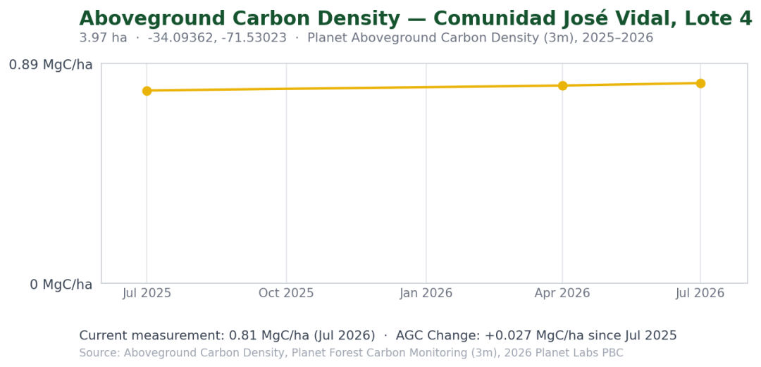
This site, Comunidad José Vidal Lote 4 (2026), measured somewhat higher than the other sites reviewed, from about 0.78 MgC/ha in July 2025 to a Current Measurement of 0.81 MgC/ha by July 2026, for an AGC Change of +0.027 MgC/ha; the highest starting-point reading of the sites reviewed so far, though still low overall and, as above, within the range where year-to-year model variability can account for the change.
The Big Picture
Across all the plots reviewed, the story is consistent: carbon density measures close to zero right now, which is what we'd expect from pre-planting land with little to no existing vegetation. That's not a disappointing result; it's the baseline we want going into planting.
From here, each future Planet Aboveground Carbon Density reading builds out the same series, letting us track carbon density over time as the trees planted through Restoring Biodiversity Highways take root and grow.
What's Next
As planting begins on these plots, we'll continue tracking the same Aboveground Carbon Density series through Planet's Platform, building today's near-zero baseline into a longer track record of the site's growth over time. We're looking forward to sharing those updates as the forest comes to life.
Stay tuned for more updates from the ground as our first Foundation project in Chile takes shape.
Comentários (0)
Deixe um comentário